
Land for Sale

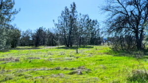
Affordable Land Acreage For Sale In California – 2 Acres Frontier Rd Oak Run $18k
Check out the YouTube Video for a great boots on the ground feel. Attractively priced rural property. Heavily forested with mature fir and pine trees. Power is located at the street. There appears to be a spring on one of the properties according to the seller. Power is available. This property is located 26 miles from Redding, CA. The elevation is about 2,700 feet. My cell phone does work here. If you want to build a home on one of the lots, you will need a well, and septic. Seller financing is not available.
Directions: From Palo Cedro, CA go 14 miles on Old 44 Dr\Oak Run Rd. Right on Oak Run To Fern Rd, at 5.5 mi keep left onto Phillips Rd go 2.7 mi. Right on Frontier Rd go .3 mi to property on left.
APN: 098-140-010-000, 098-140-032-000
Approx. GPS:
| Latitude | 40.740134 | Longitude | -121.918758 |
| Price | $18,000 |
|---|---|
| Location | Oak Run, CA |
| Lot Size | 2 Acres |
| Status | For Sale |

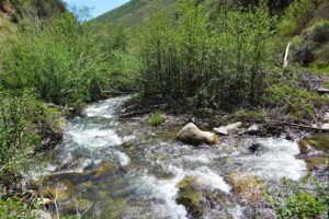
Land Acreage For Sale In California – 14575 Lower Coal Pit Rd. Igo, CA $37K
Check out the YouTube Video for this property for a great boots on the ground feel. 10 acres of rural off grid goodness. This land features about 1 acre of flat area as your build site. There is a seasonal creek at the bottom of the property that feeds a cute and humble pond. The elevation ranges from about 920 ft to 980 ft. The property is just 1 mile on a dirt road from paved Gas Point Rd and only about 15 miles from Redding, CA. If you plan to build, you will need a well, septic, and solar for this off grid country property.
Directions: From Hwy 273 in Redding, go west on Clear Creek Rd 10 miles. Left on Gas Point Rd go 2.9 mi. Left on Coal Pit Rd go .9 mi to property and pink tape on right.
APN: 045-070-025-000
Approx. GPS:
| Price | $37,000 |
|---|---|
| Location | Igo, CA |
| Lot Size | 10.1 Acres |
| Status | For Sale |

Acreage For Sale In California – Land, Lot 8 Hidden Oaks Trail Redding, CA $40K
Check out the Land Video Here. Incredible property on the outskirts of Redding. There is a nice level knoll for a possible home site with Mt. Lassen views. About 450 feet of Dry Creek runs through the property at the back. Imaging walking to the creek not far from your front door and viewing the spectacle of Mt. Lassen. From the property it is only about 5 miles to the Jones Valley boat ramp at Shasta Lake. Power at the road. Out of the snow at about 750 feet elevation. The property is about 5 miles from central Redding. Seller Financing is not available.
Directions: Hwy 299E Left on Dry Creek Rd. Go 2 mi. Left on Squaw Grass Trail. Rt on Hidden Oaks Trail go 1/2 mi to property, pink tape. Approximate Rd frontage marked with pink tape.
APN: 305-090-003-000
Approx. GPS: Latitude 40.678521 Longitude -122.244814
| Price | $40,000 |
|---|---|
| Location | Redding, CA |
| Lot Size | 6.1 Acres |
| Status | For Sale |

Land Acreage For Sale In California – Lot 8 Whispering Winds Ct Shingletown $45K
Check out the YouTube Video for a great boots on the ground feel. Here is an incredible opportunity to own a premium lot in Whispering Wood Estates Subdivision. Come listen to the wind whispering through the mature fir, cedar, and pine trees. The land is very usable without any steep slopes. All the utilities, water, sewer, and power are at the street. The roads here are paved and many homes are beautiful custom built homes. Central Shingletown is just 3/10’s of a mile from the property and it’s only 25 minutes to Redding. Located at a cool 3500 feet elevation. This property and community are part of the State Certified Fire Wise program which helps reduce risks of wildfires. Lake McCumber and Lassen National Park are not far away. Lassen National Forest has everything from Christmas tree cutting, to cross country skiing, hiking, lakes, and exploring hydro thermal areas.
Directions: Hwy 44E to Shingletown. Left on Emigrant Trail. Left on Whispering Winds Ct. Go to end.
APN: 096-300-007-000
Approx. GPS:
| Price | $45,000 |
|---|---|
| Location | Shingletown, CA |
| Lot Size | 2.6 Acres |
| Status | For Sale |

Land Acreage For Sale In California – 37.89 Acres E. County Line Rd. Whiskeytown, CA $45k
Check out the YouTube Land Video for a great boots on the ground feel. 37.89 remote acres at a forested 4900 to 5450 feet elevation. There are stunning panoramic views of Mount Shasta, Mount Bally, and Shasta Bally. This is a sweet getaway place to recreate, target shoot, relax in a hammock, or build a cabin on. The road is in good condition and two wheel drive with high ground clearance should get you there in the summer. Part of the property is in Trinity County and the other part is in Shasta County. Whiskeytown Lake is just 9 miles as the Bald Eagle flies. The property is 10.5 miles on a seasonally maintained dirt road. My cell phone does work here. The property adjoins 155 acres of Crain Mills land and 632 acres of Sierra Pacific Timber Company land to the east and to the south. On driving to the property, you will be traversing over 13,000 acres of BLM or Bureau of Land Management land. In fact, this land is about 1,000 feet away from the property in a straight line. BLM land offers a wide range of recreational opportunities, including camping, hiking, hunting, fishing, and off-roading. Other activities include horseback riding, whitewater rafting, hang gliding, and more. Many BLM lands are free to access and use, with minimal regulations compared to national parks. Seller financing is available with 20 to 25% down.
Directions: Hwy 299W to the top of Buckhorn Summit. Left on E County Line Rd (dirt)go 10.5 mi to pink tape on both sides of the road. Pink tape also marks the approximate end of the road frontage.
Approx. GPS:
| Latitude | 40.572937 | Longitude | -122.728684 |
APN: APN: 041-130-016 & 017-200-21
| Price | $45,000 |
|---|---|
| Location | Whiskeytown, CA |
| Lot Size | 37.89 Acres |
| Status | For Sale |

California Acreage For Sale – 38.6 Acres Hwy 299E, Bella Vista, CA $60K
Check out the detailed boots on the ground YouTube Video. Located in the historic town of Ingot, where in 1862 the old timers mined for silver, copper, and zinc. This property is what is known as the Afterthought Smelter where they melted the rock to extract the precious metals. Mineral rights say you get from 0 to 100 feet down. This extremely unique property includes approximately 590 feet of awesome year round Cow Creek which does contain fish. This property also has land on the west side of the highway where it adjoins 292 acres of BLM land, Bureau of Land Management. This property and some others in this area are also getting government funding for old mine/mineral remanence cleanup from the EPA in the form of a Super Fund. (No cost to owner according to the EPA news article) The elevation ranges from 1100 to 1550 feet, below the snow. Come fish, recreate, or possibly build on this truly unique property. My cell does work on some parts of the property. Owner may carry with half down.
Directions: Hwy 299 access…. From the My T Fine Food Store in Bella Vista on Hwy 299 go 11 miles to property on both sides of the road minus the legal hwy frontage. (Can’t drive into the property)
Back way, (drive in way) into the property from Oak Run, CA…. (No cars or the like) Hwy 44E to Palo Cedro, CA exit. Left on Deschutes Rd. Right on Old Forty Four Dr. go 2 miles. Straight on Oak Run Road go 15.2 miles. Left on Donkey Mine Rd go 1.8 miles. Keep left at “Y” go 1.2 miles. Right at “Y” go .3 miles. Right at “Y” go 1/2 mile to Red Posts and start of property. Go another 1.2 to reach the bottom flat part of the property near the creek.
APN: 097-090-016-000
Approx. GPS:
| Latitude | 40.722222 | Longitude | -122.080110 |
| Price | $60000 |
|---|---|
| Location | Bella Vista, CA |
| Lot Size | 38.6 Acres |
| Status | For Sale |

California Acreage For Sale – 38.7 Acres Hwy 299E, Bella Vista, CA $61K
Check out the boots on the ground YouTube Video for the most details! Located in the historic town of Ingot, where in 1862 the old timers mined for silver, copper, and zinc. This property is or adjoins what is known as the Afterthought Smelter where they melted the rock to extract the precious metals. Mineral rights say you get from 0 to 100 feet down. This extremely unique property includes approximately 580 feet of awesome year round Cow Creek which does contain fish. Also includes about ¼ acre flat area near the creek that you can drive to. Lastly, just off the hwy on the west side is a steep but less than 1/2 mile long dirt road leading up to a nice private getaway spot with views of Mt Lassen. This and other properties in this area are also getting government funding for old mine/mineral remanence cleanup from the EPA in the form of a Super Fund. (No cost to owner) There is also 38 acres of BLM land that you drive through if you go this way. The elevation ranges from 1100 to 1550 feet, below the snow. Come fish or recreate on this truly unique property.
Directions: Hwy 299 access…. From the My T Fine Food Store in Bella Vista on Hwy 299 go 11 miles to property on both sides of the road minus the hwy frontage.
Back way, (drive in way) into the property from Oak Run, CA…. (No cars or the like) Hwy 44E to Palo Cedro, CA exit. Left on Deschutes Rd. Right on Old Forty Four Dr. go 2 miles. Straight on Oak Run Road go 15.2 miles. Left on Donkey Mine Rd go 1.8 miles. Keep left at “Y” go 1.2 miles. Right at “Y” go .3 miles. Right at “Y” go 1/2 mile to Red Posts and start of property. Go another 1.2 to reach the bottom flat part of the property near the creek.
APN: 097-090-015-000
Approx. GPS:
| 40.721174 | Longitude | -122.080903 |
| Price | $61,000 |
|---|---|
| Location | Bella Vista, CA |
| Lot Size | 38.7 Acres |
| Status | For Sale |

Land Acreage For Sale In California – 1.35 Acres 1912 Cascade Blvd. Shasta Lake $65K
Check out the YouTube video I created for a great boots on the ground feel. Three separate parcels totaling 1.35 acres with easy I-5 access at under ½ mile and just 6 miles to the boat ramp at Bridge Bay Marina on beautify Lake Shasta where they rent house boats, watercraft, or storage of your own boat. There are multiple entrances the the property via different streets. There were previous structures on the property that had water and sewer and of course power, so those should still be available. The land is mostly level and at an elevation of 750 feet. According to the Assessor’s Map and neighboring lots, this property may have the potential to be 8 lots, each around 50′ by 150′. Check with the City of Shasta Lake for exact development specifics. Seller Financing is not available but a Banner Bank may loan on the land.
Directions: North to Shasta Lake City. Exit 685 Shasta Dam Blvd. Left on Cascade Blvd. Go 1/10th mile to property on right.
APN: 007-280-018-000, 007-280-017-000, 007-280-007-000
| Price | $65,000 |
|---|---|
| Location | Shasta Lake City, CA |
| Lot Size | 1.35 Acres |
| Status | For Sale |

Land Acreage For Sale In California, 40 Acres Lot 44 Jennifer Rd. Ono, CA $67K
Check out the YouTube Video for a great boots on the ground feel. Own your own 40 acres of wilderness on this rural off grid mountain view acreage. Perfect for a small ranch, getaway, or homesite. There is a permitted well on the property. Has 1/3 acre flat area with panoramic views! This property has about 600 feet of usually seasonal Wilson Creek running through at the back. Deer, wild pigs, fox, coyotes, turkeys, and quail are typical for this area. The elevation ranges from about 1560 ft down to 1000 ft at the very bottom of the property where the creek is. The property is about 4 miles on a maintained dirt road and gravel road and about ½ if it is county maintained and very nice. It’s about 35 min from Redding, CA. There is a road maintenance agreement of $260 per year and some very light CCRS (Covenants, Conditions, and Restrictions). If you plan to build, you will need a well, septic, and solar for this off grid country property.
Directions: Where Clear Creek Rd & Placer St. meet Platina Rd go west on Platina 7.4 mi, left on Bland Rd. Go 2.2 mi just past Wilson Creek Bridge. Right on Roaring Creek Rd go 1.8 miles. Right on Jennifer Rd, go to the end to gate with pink tape.
APN: 044-160-022-000
Approx. GPS:
| Latitude | 40.415522 | Longitude | -122.691502 |
| Price | $67,000 |
|---|---|
| Location | Ono, CA |
| Lot Size | 40 Acres |
| Status | For Sale |
Shasta County Land For Sale – 2 Acres 17435 Lassen Ave, Anderson, CA $70K
Watch the detailed Land Video Here. Shasta County land for sale with an excellent country feel. Level topography and generous tree cover near the back of the parcel. PGE power has been dropped onto the property since an old home was on the lot in the past. There may be an old septic but no permits found. Water at the lot frontage provided by Clear Creek Water District. Has flowering bushes and possible fruit trees. This property is just 6 miles from central Anderson and I-5. Anderson is home to the Anderson River Park and the Coleman National Fish Hatchery which is nearby. Seller financing is not available.
Directions: I-5 south to Anderson, exit North St., turn right. Left on Hwy 273. Right on South St & go 6.1 mi. Left on Happy Valley Rd. Right on Lassen Ave. Property on left at sign & pink tape.
APN: 206-360-024-000
| Price | $70,000 |
|---|---|
| Location | Anderson, CA |
| Lot Size | 2 Acres |
| Status | For Sale |

Acreage For Sale In California – 40 Acres Lot 8 Ash Creek Rd Anderson, CA $90K
Check out the YouTube Land Video for a great boots on the ground feel. 40 acres with stellar views to the south. About 26 acres is flat! Located on the east side of I-5. Open range area great for an off grid ranch, homesite, hunting, or recreation. Typical volcanic surface rock for the area which is from Mount Tehama when it erupted about 600,000 years ago. Build a ”fence” with it like the neighbor did or sell it to a landscape company? A seasonal creek runs along the front (south side) of the property. Zoning is Limited Residential. Only 30 minutes from Redding. Two ways to get to the property. Ash Creek is easy and paved but has barbed wire along the frontage. Aoudad is a dirt road requiring high ground clearance but no barbed wire.
Directions: Hwy 44E. Right on Millville Plains Rd. Left on Dersch Rd. Right on Ash Creek Rd. (Go 4.2 miles to pink tape & property on right.) OR (Go 3 miles. Right on Aoudad go .7 mi to pink tape on left.)
APN: 704-060-011-000
| Price | $90,000 |
|---|---|
| Location | Anderson, CA |
| Lot Size | 40.4 Acres |
| Status | For Sale |

Land Acreage For Sale In California, 14485 Small Farms Rd Igo, CA $115K
Check out the YouTube Video for a great boots on the ground feel. Great country acreage for your new home. There are amazing views of Mount Shasta, a seasonal creek, at least 2 springs, and two hand dug wells. At the level area of the property you will find power with a transformer, a power meter, a water pressure tank, plugins for what looks like 110 and 220 Volts. The wells located at the bottom of the property are not permitted but it might be possible to permit one. This property is located just 1.6 miles from paved Gas Point Rd and the Northern California Veterans Cemetery. Central Redding is just 14 miles away. Out of the snow at 900 feet elevation. There is about 4.5 acres of really nice topography for your homesite, ranch, and animals. The smaller parcel does lack legal creation, meaning it was split off from a larger parcel after the Map Act law passed in the 1970’s without a Map. No permits would be granted on that parcel without getting a certificate of compliance. The larger parcel does not have this issue. There is also an easement through the smaller parcel on the other side of Small Farms Road, north side, for the adjoining neighbor to reach his land. There is a power pole near the existing easement and lot line, north of Small Farms Road. Based on the Ag zoning, it appears that these parcels may have a 5 acre minimum lot size, as in they might be splitable. Check with the Shasta County Building Department for more info in that if you are interested. Seller Financing may be available.
Directions: From Hyw 273 in Redding, go west on Clear Creek Rd 10 miles. Left on Gas Point Rd go .9 mi. Left on Small Farms Rd go 1.6 mi to property, pink tape and gate a bit off the road.
APN: 045-280-061-000 & 045-280-034-000
Approx. GPS: Latitude 40.466480 Longitude -122.521169
| Price | $115,000 |
|---|---|
| Location | Igo, CA |
| Lot Size | 44 Acres |
| Status | For Sale |

Land Acreage For Sale In California – 7.88 Acres Glenbo Ln. Anderson $119K
Check out the YouTube Land Video for a great boots on the ground feel. Looking for just the right spot for your dream home? You have to come check this one out. Incredible acreage that has underground power, public water with a meter already installed, a fire hydrant, and perimeter fencing. This parcel is sprinkled with just the right mix of grey pines and oak trees to open ground. Excellent usable topography that starts to slop off toward the back which enhances your view potential. This property gives you end of the road privacy and the size of the lot adds to that nicely. The zoning is Rural Residential and appears to have the potential for a split of up to 3 lots. Check with the Shasta County Building Department for full particulars. Out of the snow zone at 700 feet elevation. My cell phone does work on the property. The property is located just 6 miles from I-5 in Redding. Seller Financing is not available.
Directions: Hwy 273 in Redding. Go west on Canyon Rd near Win River Casino. Go 2.2 mi. Right on Hawthorn Ave. Go .2 mi. Left on Glenbo and go straight to the end.
APN: 205-040-020-000
Approx. GPS:
| Price | $119,000 |
|---|---|
| Location | Anderson, CA |
| Lot Size | 7.88 Acres |
| Status | For Sale |

Land Acreage For Sale In California – Lot 30 Lack Creek Dr. Shingletown $130K
Check out the YouTube Video for a great boots on the ground feel. Improved rural acreage in the Black Butte Subdivision backing up to about 350 feet of lovely Lack Creek and with awesome Mount Shasta views. I did see many small fish in the creek. There is about 3.5 acres of level to gently sloping land at the front of the property. Come build your home amongst the oak trees and views. This property is a blank canvas to which dreams can be made. A well, septic, power and phone at the road. The septic was inspected/pumped in 2006. A well test was also performed many years ago and was at about 13 GPM. There is a cinder rock over the entrance into the property. Natural land terracing at the back of the property would be great for a garden. Lots of privacy at the back half of the property. The elevation ranges from about 1250 ft to 1400 ft. The property is just 1.9 miles on a gravel/dirt road from paved Dersch Rd and only about 15 miles from Redding, CA.
Directions: Hwy 44E toward lower Shingletown. Right on Dersch Rd go 1.4 mi. Left on Frey Rd go .9 mi. Right on Lack Creek Dr go 1 mi to property and pink tape on left.
APN: 704-140-022-000
Approx. GPS:
| Price | 130,000 |
|---|---|
| Location | Shingletown, CA |
| Lot Size | 10.4 Acres |
| Status | For Sale |

Land Acreage For Sale In California – 37.2 Acres Backbone Rd Bella Vista $139K
Check out the YouTube Land Video for a great boots on the ground feel. 37.2 remote acres with stupendous picture framed views of Lake Shasta and Mount Shasta! This property would make a great weekend get-away or bug out spot. While on the land, a Bald Eagle even flew overhead. This property is fortified with a large shed and an unfinished shell that looks like a cabin on the outside. The shed is 12×24 and built around 2015. The shell structure is 14×40 and built in around 2009. These are not livable structures and given no value. The value is in the land and the amazing views. There are no permits for these structures and there is no well, septic, power or solar on the property. There is room for RV parking. There is some interesting history in the matter that our 30th president, Calvin Coolidge who served from 1923 to 1929 reserved in patent #941271 the mineral rights of this property. The elevation ranges from about 1450 ft to 1620 ft. The property is 4 miles on a dirt road from paved Hwy 299E and the road has seen recent maintenance work but a high ground clearance vehicle is still recommended. It’s about 20 miles from Redding, CA at I-5. There are 10 items listed as CCRS from 2003. Lake Shasta is just over 1 mile away as the Bald Eagle flies.
Directions:
Shown by appointment to qualified buyers. Hwy299E from Redding & I-5. From the My T Fine Food Store in Bella Vista, go 9.4 miles to a left just after the Diddy Wells Fire Station, Seamen Gulch Rd go 2.9 mi. Left on Backbone Rd go 1 mi. Left at locked Wilcox Ranch Gate. Go right at all “Y”s in the road.
APN: 097-140-019-000
Approx. GPS:
| Latitude | 40.721117 | Longitude | -122.142734 |
| Price | $139,000 |
|---|---|
| Location | Bella Vista, CA |
| Lot Size | 37.2 Acres |
| Status | For Sale |

Land Acreage For Sale – 320 Acres Vestal Rd Red Bluff, CA $195k
Check out the YouTube Video for a great boots on the ground feel. Awesome property if you want a super low tax bill. The ideal use of this land is agriculture, open space, hunting, recreation, or cattle use. Salt Creek runs through the property at a length of about ½ mile. As of August 4th 2025 there is water in several spots along the dry creek bed, my best guess is that these may be springs. The property appears to be located in the Williamson Act which allows for less taxes in exchange for less development, like open space, recreation and agriculture. The property taxes for this property in 2024 was just $428 for the entire year. It may be possible to live on the land but you would need to check into the details with the Tehama County Building Department to make that happen. The elevation goes from 1100 to 1400 feet. The property is located on a nice dirt road with a creek that you drive through a few times before reaching the property. My cell phone does not work well here. The property is located 36 miles from Red Bluff, CA at I-5.
Directions: From Red Bluff, CA take exit 631 and head west on Hwy 36 toward Platina, CA. Go 31 miles. Left on Vestal Rd, no sign. At 4.3 miles stay left go .6 miles to property on right and pink tape along road frontage. Path into property another 1/10th mile.
Approx. GPS: Latitude 40.238272 Longitude -122.715905
APN: 001-260-042-000, 001-260-045-000
| Price | $195,000 |
|---|---|
| Location | Red Bluff, CA |
| Lot Size | 320 Acres |
| Status | For Sale |

Shasta County Land For Sale, 398 Ac Trinity Mountain Road, French Gulch, CA $299,000
Watch the very informative YouTube Land Video. Owner Financing is available for up to 3 years with 25% down. Own a large part of historic French Gulch including about a half mile of Clear Creek. French Gulch was founded by French miners in 1849 and became one of California’s major gold producing areas. There appears to be 2 or more mines on the property along with old creek tailings. The mines are the Dudley and part of the Hughes mine. There are mineral rights according to the title company who researched it for me. I do not know the exact location of the mines or any other details when researching them with the county building department and the title company. Stunning views for miles! Adjoins government land on 3 sides total. Two sides have over 31,000 acres of BLM land and the other side has over 41,000 acres of National Park Service Land. This property was in the 2018 Carr Fire. You pass by Whiskeytown Lake just before you get to the property. It is 15 mi to Redding. The Whiskeytown Lake area has boating, swimming, fishing, a beach, and many hiking trails with 4 leading to awesome waterfalls. I have been to 3 of them and can attest to their worthiness of the hike. The elevation goes from 1300 ft to about 2600 feet and is on both sides of Trinity Mountain Rd. There is a small PGE power station that adjoins the property and has an easement for access and lines.
Directions: At Eureka Way & Buenaventura Blvd go West about 14 mi. Rt on Trinity Mountain Rd. go 1.5 mi to property on rt & left. Property on left ends near Tom Green Mine Rd. PGE station next to pond on rt.
Approx GPS: 40.68593, -122.64076
APN: 046-290-024, 046-290-026
| Price | $299,000 |
|---|---|
| Location | French Gulch, CA |
| Lot Size | 398 Acres |
| Status | For Sale |
Shasta County Land For Sale 635 Acres French Gulch Rd, French Gulch, CA $299K
Check out the Land Video to see the property in full detail. One full section of mostly steep land but with several great features including power along the bottom road. First, it is completely surrounded on all 4 sides by 6,700 acres of government land. Second, there are springs and year round French Gulch Creek! Lastly, there is power to at least 2 possible build sites. Both roads running though the property are county roads according to the title company. Cell coverage on the upper road. In 1850 French Gulch was one of California’s major gold producers and at least 2 are still active today and located just up the road from the property. Both approximate road frontages are marked with pink tape so you can see where the property starts and stops. Elevation ranges from 1600 feet to 3000 feet at its highest peak. Owner may carry with 20% down for 5 to 10 years.
Directions: Hwy 299W to French Gulch. Right on Trinity Mountain Rd go 2.9 mi. Left on French Gulch Rd go 1 mile to Pink tape and RE sign. Or go 2.6 miles from main road. Left on Tom Green Mine Rd go 1.7 miles.
APN: 046-280-001-000
Approx. GPS:
| Latitude | 40.707086 | Longitude | -122.661558 |
| Price | $299,000 |
|---|---|
| Location | French Gulch, CA |
| Lot Size | 635 Acres |
| Status | For Sale |